In 2011, while working at 3D Robotics, I was flying my drone over a park when I captured an image that would not only change my life, but also how I thought about drones. Using software made to stitch panoramas, I put together a map of the park and quickly realized how perfect and cost-effective drones would be for capturing data.
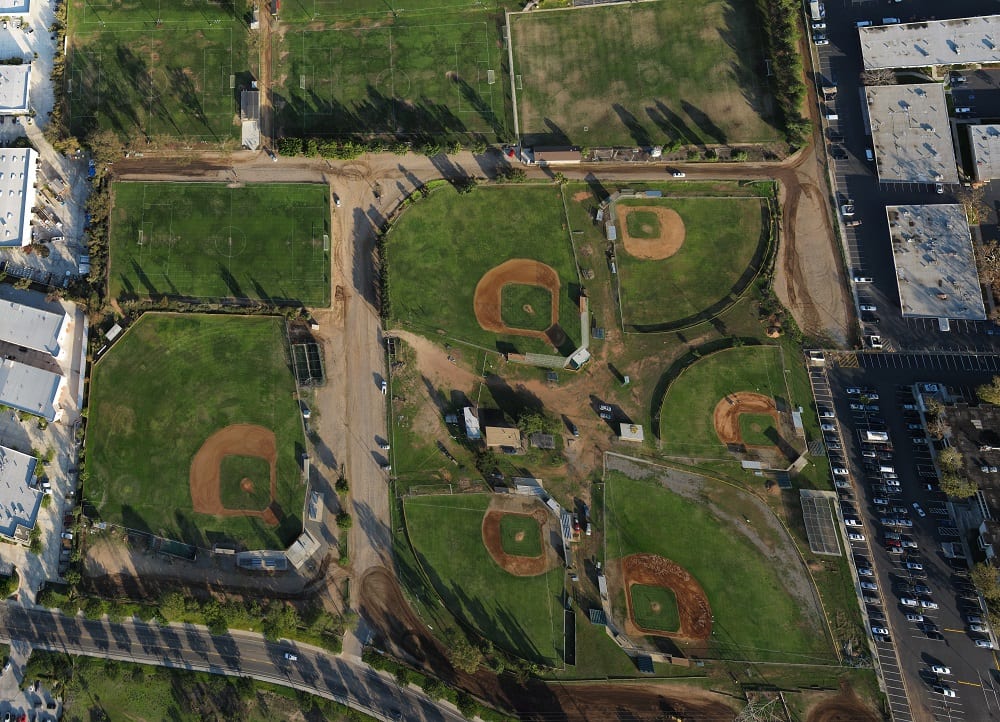
ASCII Kolor stitching | 100 pictures | Size: 13822 x 19143 | FOV: 44.37 x 55.77 ~ 19.22 | RMS: 3.64 | Lens: Standard | Projection: Planar | Color: LDR
The details in this image blew me away. You can even zoom in and see someone raking the dirt on the baseball diamond. You can measure the size of the baseball diamond, and look at the grass and see how well it’s growing. I realized immediately how difficult and costly it would be for anyone to get the same image without a drone.
It was so clear to me that individuals and businesses would be able to extract great value from aerial data using drones. This observation prompted me to start Event 38.
Fast forward four years later and not only are drones capturing valuable data, but the data is also incredibly varied. A few of the many interesting ways in which drone data is being used include:
- Crop Scouting a 75-acre cornfield in central Ohio
- Archaeology Expedition: Identifying and locating potential sites for excavation
- Saving Spider Monkeys in Ecuador through Forest Monitoring
- Determine the feasibility of the construction of a hydro-power plant in Uganda
Being able to capture data more frequently, cost effectively and accurately has created a new field of micro remote sensing. Unfortunately, the amount of value that can be extracted from this data has been limited. This is because the tools needed to geotag data, stitch images, run deeper analyses, and even just to explore the imagery have been a patchwork of open source projects and expensive software packages. If you don’t have a background in GIS imaging or software development, even the simplest imagery post-processing tasks can be time consuming and difficult.
Here at Event 38, this is something we kept hearing from our customers, partners and resellers. They were very happy with our drones, sensors and support. Being able to capture data frequently was something they saw great value in. However, using a hodgepodge of post-processing software, opening a 2GB geotiff on their PC and sharing files via a USB drive wasn’t the greatest experience.
To solve this problem and to offer our customers a better experience, we recently announced our Drone Data Management System™ public beta. The DDMS is a cloud-based set of tools that store, analyze and share data collected by any drone. DDMS streamlines the entire map post-processing workflow. Upload, Process, Analyze and Share. DDMS automatically creates a geotagged orthomosaic and tiles large maps to be viewed quickly in Map Viewer, our online map tool. DEMs, NDVI and DVI calculations can be added as well. All processing results are available as high resolution originals in geotiff format, so you can continue to work with your existing GIS tools. Anything that you process in DDMS can also be privately shared with friends, clients, colleagues and advisors. In the future, we’ll be adding time series analysis, crop stand counts, topographic map exports and ground control point editing.
DDMS YouTube video
Managing data and returning a measurable value to users is the next great challenge in the widespread adoption of drones in business. As we go forward, it’s clear that we need a new set of tools to automate image analysis at this scale. Existing tools mostly focus on the parcel-level and higher because sensors haven’t been able to gather the same level of detail that drones can. Now that we can capture imagery that differentiates leaves on a plant or chips in cement, there is a huge opportunity to solve problems that wouldn’t traditionally use aerial data. As we build new analysis techniques for data at drone scale, we’ll unlock hundreds, if not thousands, of new applications for remotely sensed data.
It’s such an amazing time right now and we’re very excited to be part of the Dronecode Community! Please feel free to contact me anytime with any questions or feedback.
Thank you!
Jeff
ABOUT THE AUTHOR OF THIS POST
Jeff Taylor is the Founder of Event 38. Founded in 2011 and with customers all over the world, Event 38 designs and manufactures drones, specialized optical sensors, and a Drone Data Management System™ for Construction, Environmental Conservation, Mining, Surveying and Precision Agriculture. Jeff has been fascinated by Flight and Space ever since he was a little kid. Right after graduating college, Jeff joined SpaceX as an electrical engineer where he helped launch and recover the first commercial space capsule to re-enter Earth’s atmosphere. He was also previously the Director of Research and Development at 3D Robotics.